|
COMMAND AND MISSION
On
February 1, 1864, about 1,500 Union soldiers under Colonel William
A. Phillips (Fig. 1) set out from Fort Gibson, Indian Territory on
an expedition to cut a swath through Confederate Indian Territory
from the Arkansas River south to Red River. Col. Phillips little
army was composed of a well-armed battalion of Kansas cavalry and
two regiments of Indian Home Guard (IHG), supported by a section of
howitzers from Capt. Solomon Kaufman’s Company L (artillery company)
in the 3rd IHG. The 1st IHG (composed of
Creek and Seminole Indians) was commanded by Col. Stephen H.
Wattles, and the 3rd IHG (mostly Pin Cherokee Indians) by
Major John A. Foreman.
Colonel Phillips’ mission was to
bring Indian Territory under Union control and offer amnesty to the
Creek, Seminole, and Chickasaw Indians provided in President
Lincoln's Emancipation Proclamation of the previous December. Colonel Phillips also wanted to sever
Confederate treaties with the tribes and gain new recruits. With
his western flank safe, in April he planned on returning and
crushing the rebel Choctaw’s.
Before departing Fort Gibson for Fort
Washita and perhaps North Texas, Col. Phillips told his men,
"Soldiers! I take you with me to clean out the Indian Nation south
of the (Arkansas) river and drive away and destroy rebels. Let me
say a few words to you that you are not to forget ... Those who are
still in arms are rebels, who ought to die. Do not kill a prisoner
after he has surrendered. But I do not ask you to take prisoners. I
ask you to make your footsteps severe and terrible. Muscogees!
(Creeks) the time has now come when you are to remember the authors
of all your sufferings; those who started a needless and wicked war
... Stand by me faithfully and we will soon have peace ..."
Phillips proposed march followed much
of the little used 1855 “Dragoon Trail” of US 2nd Cavalry
fame, which lay west of the overused Texas Road. Col. Phillips
chose this route for two reasons: (1) the Dragoon Trail headed
directly (from Ft. Gibson) toward all three Indian nations he wished
to control, and (2) he expected to find more forage and corn along
it to feed his little army, which he did. Three companies (B, L, &
M) of the 14th Kansas Cavalry led by Major Charles Willetts served
as the spearhead of Phillips’ Expedition. During the month long
campaign, the Federals subsisted off the land, raided Indian
settlements, and fought one savage battle—The Battle of Middle
Boggy.
Figure 1. Col. William A. Phillips,
Federal Commander of Phillips Expedition. Source: Territorial Kansas
History--Online.
RAIDS THRU CREEK AND SEMINOLE
NATIONS
Col Phillips marched southwest along
the Dragoon Trail for two days, finding few rebel Creek Indians and
little corn. On February 3, Phillips left the Dragoon Trail at
Council Grounds (Fig. 2, near Council Hill, OK) and marched his
little army south raiding the Creek settlements of the Canadian. He
camped around Hillabee (near Hanna) on February 4th for four days
waiting for the remaining nine companies of the 14th
Kansas Cavalry to arrive from Ft. Smith. Phillips reported that 7
rebels had been killed and a similar number captured during his
drive to Hillabee (Camp Willetts), primarily because Creek forces
under Colonel Chilly McIntosh and Lt. Col. Pink Hawkins had fled
south toward the Wichita Mountains and Red River.
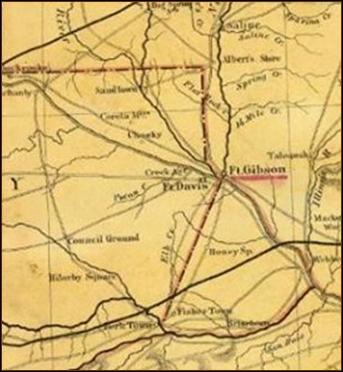
Figure 2. Segment of 1869 Map Showing Road from Ft. Gibson
Southwest to Council Ground then South Across Deep Fork into
Southern Creek Country.
Source: McCasland Maps, OSU Digital Library.
Col. Phillips camped around Hillabee
(Fig. 3) for four days waiting for the large 14th Kansas
battalion to arrive from Ft. Smith.
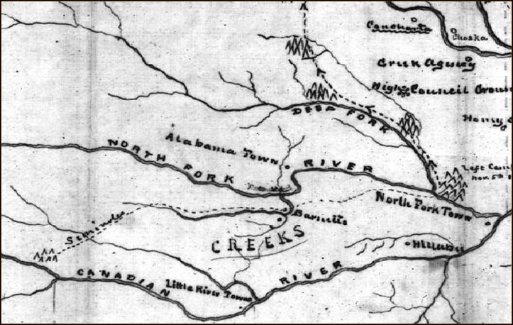
Figure 3. Segment of 1863 map drawn
in Ft. Gibson showing Federal view of where Seminoles and Creeks
were located west of Hillabee. Barnett’s is near Wetumka, OK.
Source: Federal Records.
On the 5th, Phillips sent
three cavalry columns west to clear out rebel Seminoles and Creeks
living up the Canadian River tributaries, particularly Little
River. Nearly 100 rebels were reportedly killed during the first
four days of these cavalry raids on Creek and Seminole settlements.
Waiting no longer for the extra cavalry, the main Union army marched
southwest (probably along the old Beale Wagon Road, Fig. 4) thru
several smoldering Creek settlements to rejoin the Dragoon Trail.
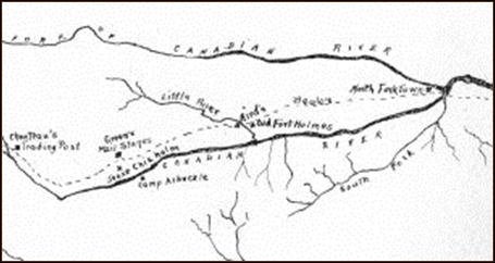
Figure 4. Old Beale Wagon Road. Source: Grant Foreman, Chronicles
of Oklahoma, Vol. 12, No. 1, p. 74.
Phillips rejoined the Dragoon Trail
near Oak Ridge Mission just prior to reaching the north bend of the
South Canadian River at old Fort Holmes near Edwards Post at the
mouth of Little River. The old fort was located five miles
southeast of Holdenville, OK and 105 miles from Fort Gibson. Here
Colonel Phillips camped for the night to consolidate his forces,
while continuing to hope for the arrival from Ft. Smith of the
remainder of the 14th Kansas Cavalry commanded by Colonel Thomas
Moonlight. The total casualty count for this phase of Phillips’
Expedition was well over 100 rebel Creek and Seminole Indians. The
Confederate commander of Indian Territory, MG S. B. Maxey, later
claimed that at least one woman and child were killed in their camp.
PHILLIPS CROSSES SOUTH CANADIAN
With the return of his own cavalry
raiders into the Seminole Nation, on 2-12 Colonel Phillips sent the
1st IHG south across the South Canadian to begin his
advance down the Dragoon Trail southwest (S20W) toward Shawnee Town and Middle
Boggy River, about 19 miles away. Col. Wattles’ advance was
supported by the two howitzers of Captain Kaufman’s artillery. The 3rd
IHG (Phillips old command) followed Phillips’ wagon train as a rear
guard. Federal scouts and infantry were now entering the extreme
northwest corner of the Choctaw Nation.
Five miles south of the river (near Atwood, OK), the Dragoon Trail
joined the Marcy Trail (California Trail) for about 10 miles while
climbing past Shawnee Town (north of Allen) then down to a road
junction (near Allen). Nearby were located Motes Springs
(campgrounds) and the northern headwaters (Little Sandy Creek) of
Middle Boggy. An eastern short-cut of the Marcy Trail (the newer
Ft. Smith-Ft. Arbuckle supply road from Gerty/Stuart) joined the
Dragoon Trail (at Allen). The old and little used (in 1864) Marcy
Trail proceeded southwest along the Shawnee Hills toward Ada. OK 1
highway follows the Marcy Trail from Atwood thru Allen toward
Delaware Mount (near Ada). This legacy (1849-59) western trail then
passed Camp Arbuckle of 1850-51 (2 miles NW of Byars) on its way to
Santa Fe, NM and California.
Proceeding S20W four miles past Allen junction along the eastern
side of Little Sandy Creek, the Dragoon Trail (double red line in
Fig. 5) crossed Middle Boggy (whose western headwaters are near Ada)
just below both the mouth of Little Sandy and the formal
Chickasaw/Choctaw Boundary of 1855 (vertical red line in Fig. 5).
From the crossing, the Dragoon Trail headed southwest about 17
miles to a rock ford of the Clear Boggy just below the mouth of Bois
d`Arc Creek (near old Stonewall, Colbert Institute and Cochran’s
Store). The Ft. Arbuckle military road continued southwest past
Cochran’s Store (and Trading Post) to Fort Arbuckle (near Davis).
Near Cochran’s Store, the Dragoon Trail turned south between Clear
Boggy and Blue River to Fort Washita. After the War, the Dragoon
Trail became the “Texas Cattle Trail” to Kansas. The Trail followed
the eastern side of the Blue River through Johnston County until it
crossed the Blue near Milburn.
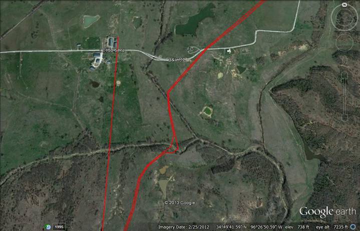
Figure 5. Dragoon Trail (Texas
Cattle Trail) Crossing of Muddy Boggy River Just East of the
Chickasaw | Choctaw National Boundary, US BLM Initial Survey of
1871. Source: Google Earth.
CONFEDERATE WINTER DEFENSE LINE
By February 10, 1864, the Confederate
high-command of Indian Territory had deployed its available troops
along an east-west line to defend (North Texas) against possible
Federal invasion from either Ft. Smith or Ft. Gibson. The
Confederate southern defense line in Indian Territory (for the
winter) ran from Ft. Washita eastward along the north side of Red
River through Boggy Depot, Ft. Towson and on east to Laynesport,
Arkansas. Almost all of the troops west of Laynesport were Indian
units commanded by Brig. Gen. (BG) Douglas H. Cooper (Fig. 6). BG
Richard Gano’s new Texas Brigade had just made camp in extreme
southeastern Indian Territory near Laynesport on Red River. Small
reserve units (e.g., Quantrill’s Raiders) were camped for the winter
along Red River and in North Texas. Western frontier defenses
(against Plains Indian raids) were posted along a north-south line
from Seminole Agency southward through Cherokee Town to Fort
Arbuckle. The Seminole Battalion under LC John Jumper primarily
manned this western line.
Jumper’s other command, a squadron
from the Chickasaw Battalion provided a northern picket line of
cavalry patrols from Seminole Agency eastward through Cochran’s
Store northeast along the Dragoon Trail to an outpost at the
national boundary at Middle Boggy, near Little River. Patrolling
the next forty miles along the old Marcy Trail east along the South
Canadian to Col. Stand Watie’s picket station on the Texas Road
above Perryville depended on weary Creek troopers under Col. D. N.
McIntosh. Most of these troopers fled with their families at the
first sign of Phillips invasion. Those few brave warriors that
stayed to their posts were killed. Thru this gap in the northern
picket line marched Phillips’ entire Federal Army.
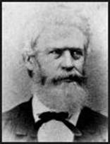 Figure 6. BG Douglas H. Cooper, Commander of Confederate Indian
Division, February 1864. Source: Oklahoma Historical Society (OHS).
Figure 6. BG Douglas H. Cooper, Commander of Confederate Indian
Division, February 1864. Source: Oklahoma Historical Society (OHS).
Phillips line of march and time of
attack caught the Confederate high-command of Indian Territory
totally off guard. For example, a major Grand Council of the United
Nations (of Confederate Indian Tribes) started on Monday, February
1, 1864 at Armstrong (Choctaw) Academy and lasted without
disturbance until Wednesday, February 10. CSA’s Commander of
Indian Territory, MG S. B. Maxey (Fig. 7), gave the keynote address
on Friday, February 5, attended by BG Cooper. Phillips expedition
was across the South Canadian River and had attacked Confederate
forces at Middle Boggy on Saturday morning February 13, 1864 before
CS BG Cooper, who fortunately had returned to his HQ at Boggy Depot,
heard about Phillips’ attack only 45 miles away late that evening.
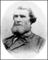 Figure 7. MG Sam Bell Maxey, Confederate Commander of Indian
Territory, February 1864. Source: OHS
Figure 7. MG Sam Bell Maxey, Confederate Commander of Indian
Territory, February 1864. Source: OHS
JUMPER’S “REGIMENT”
One commander who knew he was being
attacked was (Confederate) Seminole Chief Lt. Col. (LC) John Jumper
(Fig. 8), commander of the western Frontier defense line (against
Plains Indians). Jumper’s loosely organized new cavalry “regiment”
(for Frontier duty) was composed of his Seminole Battalion and the
Chickasaw Battalion, under the command of LC Lemuel M. Reynolds.
While Jumper’s Seminole Battalion was composed mostly of Seminole
Indians (and maybe still some Creeks), the Chickasaw Battalion
consisted of a small number of unlettered companies (at the time)
filled with Chickasaw and Choctaw Indians together with over fifty
whites (mostly from north Texas and western Arkansas).
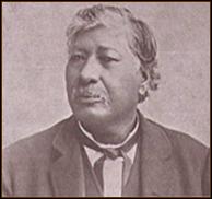 Figure 8. Lt. Col. John Jumper, Commander of Seminole Battalion,
February 1864. Source: OHS.
Figure 8. Lt. Col. John Jumper, Commander of Seminole Battalion,
February 1864. Source: OHS.
One such company at the Battle of
Middle Boggy was commanded by Capt. Jonathan Nail (Fig. 9), a
Choctaw, who had a station stop on the Butterfield Overland Mail on
the Blue River south of Boggy Depot. This company, formed during
the war by Capt. Jonathan Nail and Lt. Walker Martin, soon joined
the Chickasaw Battalion where it was known during the war as “Nail’s
Company.” Nail’s Company is not to be confused with Company A of
the 1st Choctaw and Chickasaw Mounted Rifles that was
originally commanded by Capt. Adam Nail, Jonathan’s younger
brother. Adam Nail reportedly died in late 1861 of unknown causes.
 Figure 9. Captain Jonathan Nail, Chickasaw Battalion, February
1864. Promoted to Major, October 1864. Source: OHS
Figure 9. Captain Jonathan Nail, Chickasaw Battalion, February
1864. Promoted to Major, October 1864. Source: OHS
Several months after the Battle of
Middle Boggy, the Official Records state that the “Chickasaw
regiment” was allowed to remain at Cochran’s for reorganization.
This occurred in October 1864 when Capt. Jonathan Nail was promoted
to Major under new a Chickasaw commander, LC Martin Shecoe. Some
of the Chickasaw Battalion probably was camped around Cochran’s
Store on February 10, as they routinely patrolled the northern part
of their Nation (along the southern side of the South Canadian) from
Seminole Agency nearly to Little River Town. HQ of the Chickasaw
Battalion, under LC Reynolds, at this time was likely near Ft.
Washita while guarding the northern approaches to their Capitol of
Tishomingo. Practically speaking, the Chickasaws guarded the
north-south road to their capitol, and the Seminoles likewise.
The small town of Cochran, located
about 30 miles north of Tishomingo on the Dragoon Trail, contained
both governmental buildings and schools of the Chickasaw Nation.
Cochran’s (or Pontotoc to most Chickasaws) was a Chickasaw town,
home to their current governor, Winchester Colbert. Gov. Colbert
had a home two miles west of Cochran’s Store, near a small
neighborhood school. This school may have provided winter quarters
to Governor Colbert’s home guard, or “first” company of the
Chickasaw Battalion. Colbert Institute, Gov. Colbert’s
pride-and-joy, was a new National Academy (boarding school) located
near the Dragoon Trail a mile east of Cochran’s Store across Clear
Boggy River. The Pontotoc County Court House and Post Office were
located at/near Cochran’s Store and Trading Post.
Cochran’s had many roads radiating
out from the seat of Pontotoc County, Chickasaw Nation, as shown in
Figure 10. The Dragoon Trail headed northeast past Colbert Institute
to old Fort Holmes with connections to Fort Gibson and eastward to
Fort Smith. A horse trail also went southeast direct to Boggy Depot
from the school. Other roads from Cochran’s went to Cherokee Town
(going west past Gov. Colbert’s to Seminole Agency and Ft. Cobb),
Ft. Arbuckle, and (the Dragoon Trail south to) Ft. Washita. The
most likely winter quarters for Nail’s Company of the Chickasaw
Battalion were at Colbert Institute. The new (as of 1858) Chickasaw
school had two large buildings (a dorm and a school house) available
for sheltering Nail’s Company of Choctaws, Chickasaws and Texans.
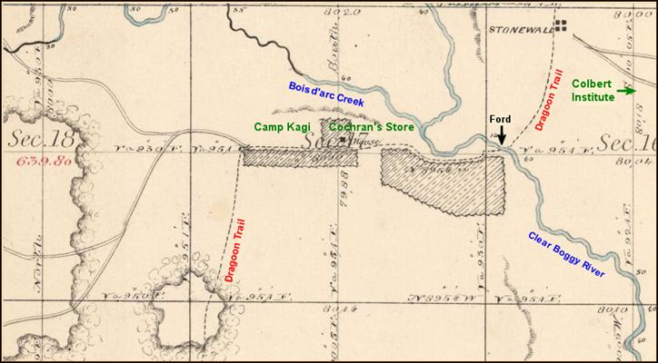
Figure 10. Cochran Store and
Pontotoc Post Office along Dragoon Trail at Clear Boggy River
Crossing. Source: US BLM, Initial Land Survey, 1871. Add ins by
Bruce Schulze, Kingston, OK.
OUTPOST AT MIDDLE BOGGY
From the Colbert Institute camp,
Capt. Nail (a Choctaw) probably selected the initial outpost on the
Dragoon Trail on the east side of Middle Boggy to picket. This
strategically important site was just across the Choctaw/Chickasaw
national boundary line (of 1856). The Line was widely recognized as
being the Dragoon Trail ford of the Middle Boggy River (Fig. 11).
Gov. Colbert may have also suggested the site, as he was very
familiar with the Road to Perryville, where his former home and
Colbert Institute were located until Perryville became officially
“not Chickasaw country” in 1856. If Union invaders were defeated on
the east side of Middle Boggy River crossing, the “polluters of our
soil” would have been “Kept Out of the Chickasaw Nation” so Gov.
Colbert would be easily re-elected later that year.
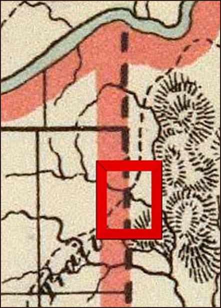 Figure 11. Clip from 1879 Map Showing Boundary Between Chickasaw
and Choctaw Nations Near Texas Cattle Trail Crossing of Middle Boggy
River just below South Canadian River. Source: Ken Martin,
Bartlesville, OK.
Figure 11. Clip from 1879 Map Showing Boundary Between Chickasaw
and Choctaw Nations Near Texas Cattle Trail Crossing of Middle Boggy
River just below South Canadian River. Source: Ken Martin,
Bartlesville, OK.
As the Seminole Nation was being
attacked by Phillips’ raiders by February 9, Lt. Col. (LC) Jumper
surely began moving some of his Seminole Battalion from its Frontier
duty into his homeland to protect his people and repel the
invaders. However, Union dispatches of the battle indicate that LC
Jumper had moved most of his command back south across the Canadian
River to support the Chickasaw Battalion blocking the Dragoon Trail
above Cochran’s by the morning of February 13. It appears that
some of Jumper’s Seminole Battalion had made camp fairly close to
the battlefield, perhaps at an Indian settlement known as Red
Springs located only a few miles south of Middle Boggy along the
Dragoon Trail toward Cochran’s. Leading elements may have camped at
Middle Boggy during the previous evening. While some of Jumper’s
Seminoles undoubtedly rode thru Cochran from its western Frontier
camps and Ft. Arbuckle as the battle approached, they did not
likely camp at Pontotoc (Cochran’s) out of respect for the
Chickasaws. Advanced camps along nearby Owl Creek (north of new
Stonewall) and at Red Springs along the Dragoon Trail were the most
likely sites.
Scant records indicate that some
troopers from Jumper’s command had established a picket station at
Middle Boggy by the afternoon of February 12, most likely by
troopers from Nail’s Company (because of its location and Jumper’s
other operations to the west and north). Scouts from Company L of
the 14th Kansas Cavalry, serving as the vanguard and
daily camp locator of Phillips’ Expedition, encountered these Rebel
troops, then perhaps only a squad commanded by Lt. Walker Martin,
blocking the Dragoon Trail at Middle Boggy late in the afternoon of
February 12. Both sides reported back that evening that a small
force of enemy cavalry was encountered near Middle Boggy. Probably
only LC Jumper at that moment (if present at Cochran’s) would have
immediately understood the danger of such a sighting of Federal
scouts along the Dragoon Trail. Surely, more Confederate troops
advanced from their camps around Cochran’s toward Middle Boggy
during the evening. Those cavalry, advancing from around Cochran’s
or closer, arrived in time for the battle.
Major Willetts, commanding the 14th
Kansas Cavalry battalion, prepared to attack early the next morning
with his entire battalion plus Kaufman’s artillery. The 14th
Kansas prepared to get its revenge for Quantrill’s Massacre of
Company A at Baxter Springs, Kansas the previous October 6.
BATTLE OF MIDDLE BOGGY
Early on Saturday morning February
13, 1864, Col. Phillips sent most of his refreshed Federal cavalry
of about 350 well-armed men under Major Willetts for a
well-coordinated, early morning attack on the remote outpost at
Middle Boggy. The site was a few miles ahead of the main Federal
line of march where Willett’s column passed Wattle’s 1st IHG
infantry bivouacked several miles north of Allen about dawn. This
strike force consisted mainly of the three companies (B, L, & M) of
the 14th Kansas Cavalry. Confederate forces at the outpost that
morning, probably under the command of Captain Jonathan Nail, may have numbered as many as 90
poorly armed Rebels who had no artillery. It appears that most of
Capt. Nail’s Company of the Chickasaw Battalion and perhaps half of
LC Jumper’s Seminole Battalion had arrived as the battle began, as
announced by an opening salvo of Federal artillery fire. Union
commander Col. Phillips’s subsequent dispatches indicate that he
believed that LC Jumper, himself, was at the battle. Rebel MG S.B.
Maxey, commander of Indian Territory, following a personal interview
with BG Cooper (and probably Capt. Nail) at Boggy Depot, later
reported to LG Kirby Smith that both Nail’s Company (of Chickasaws,
Choctaws, and Texans) and Jumper’s Seminoles had suffered several
fatalities. Records indicate that the only Confederate soldiers who
fought in the battle were LC Jumper’s troopers from the Chickasaw
Battalion and the Seminole Battalion. (The 20th Texas
Cavalry-dismounted were all serving garrison duty at Boggy Depot as
infantry and were unaware of Phillips’ Expedition. All other units
of BG D.H. Cooper’s Indian Division (besides Jumper’s Frontier
“regiment”) were serving along the southern defense line along Red
River, or on related picket duty toward Ft. Smith.)
LC Jumper’s Confederates were stunned by the Federal artillery fire
and Willetts’ well-armed cavalry charge. The Confederates fought
desperately for about thirty minutes before retreating down the
Dragoon Trail southwest toward Cochran and the rest of LC Jumper’s
Seminole Battalion. Only 20 of Jumper’s Seminoles reportedly
retreated thru Cochran and rode on toward Ft. Arbuckle. During the
evening, it appears that the remnants of Nail’s Company fled south
to Boggy Depot, and the remainder of the Chickasaw Battalion still
camped near Cochran guarded the evacuation of Gov. Colbert’s family
from Pontotoc south to Tishomingo and Fort Washita. The retreating
Chickasaws soon joined the rest of the Chickasaw Battalion,
commanded by LC Lemuel Reynolds, near Colbert’s Mill and Rock
Academy (a Chickasaw National Academy) guarding the northern
approaches to Tishomingo, the Chickasaw Capitol. The Dragoon Trail
passed midway between the two sites (located about 16 miles apart)
on its way south to Ft. Washita. BG Cooper had gone to Ft. Washita
on the 11th from the Grand Council at Armstrong Academy
to deal with a prison escape. Shortly thereafter, Cooper returned
to his HQ at Boggy Depot (located about 45 miles from the battle).
During the night of the 13th, BG Cooper at Boggy Depot
was informed by Capt. Nail of the shocking defeat at Middle Boggy
and Union advance toward Cochran’s Store (near old Stonewall).
Capt. Jonathan Nail must have performed bravely in the battle
because he soon would be promoted to Major of the reorganized
Chickasaw Battalion, under a new commander. BG Cooper gets a second
dispatch on the morning of the 15th that the Federals
have advanced to within 25 miles of Boggy Depot (at Cochran’s
Store). Cooper immediately asked for more reinforcements from North
Texas.
Major Willetts, following the directives he had been given by Col.
Phillips, had taken no prisoners in the Battle of Middle Boggy. The
bodies of the wounded that Capt. Nail was forced to leave unburied
on the battlefield were discovered later by a Confederate burial
detail to have had their throats cut. The Federals initially
reported 47 Confederate killed, later increased to 49. BG Cooper
reported 11 Confederates died, including 4 from Nail’s Company.
Major Willetts reported no Union casualties in the Battle of
Middle Boggy. No bodies from the battle or from a burial ground
have ever been found.
Col. Phillips camped on the northeast
side of Middle Boggy River the night following the battle, naming
the site Camp Kansas. Phillips’ dispatch to Ft. Smith the next
morning (2-14) showed that he believed he was in the Choctaw Nation.
The Dragoon Trail south of the Middle Boggy crossing to near Ft.
Washita had been the defacto (district) boundary between the
Chickasaws and Choctaws from 1837-1855, (when a new treaty was
approved). This segment of the Trail became the practical national
boundary from 1856 until 1872 when a federally approved initial land
survey of the Chickasaw Nation was completed. This new north-south
(meridian) boundary line would lie only 0.3 miles west of the Trail
crossing of Middle Boggy.
AFTER THE BATTLE, PHILLIPS’ MISSION
CHANGES
The morning after the battle, Col.
Phillips knew that the remaining 9 companies of the 14th Kansas
cavalry were not coming. (Seven companies of the 14th
Kansas, under Major John G. Brown, had been camped for several days
nearly 80 miles east along the South Canadian, a few miles west of
Whitefield, OK, while their scouts looked for Phillips. Two
companies were held at Ft. Smith for patrol duties. Never finding
Phillips, they broke camp on February 14th and headed
back to Ft. Smith.) Believing the Confederates would soon
concentrate against him along Red River, Phillips concluded that
invading North Texas now was not feasible; however, attempting to
communicate President Lincoln’s new amnesty proclamation to the
Confederate Indians was still possible.
Col. Phillips divided his command.
He sent his mounted forces under Maj. Willetts south along the
Dragoon Trail 21 miles (probably measured from Phillips’ HQ at Camp
Kansas) pursuing the fleeing Confederates and seeking Chickasaw Gov.
Winchester Colbert, who resided near Colbert Institute and the
(seldom used) Pontotoc District Court House near Cochran’s Store on
Clear Boggy. Col. Phillips followed Willetts’ van and camped that
evening at Camp Kagi (John Henry Kagi was a John Brown martyr at
Harpers Ferry) on Clear Boggy (1.5 miles southwest of old Stonewall)
near Cochran’s Store. Phillips also ordered Col. Wattles to take
the remainder of the straggling command (mostly Indian infantry
since only the 1st IHG had reached Middle Boggy
battlefield the afternoon of the battle) and return to old Ft.
Holmes, which Col. Wattles did late in the evening of 2-14.
At Camp Kagi, Col. Phillips sent one
Rebel prisoner with two squads (about 50 men each) of cavalry south
along the Dragoon Trail toward Ft. Washita and Boggy Depot. The
prisoner was ordered to deliver the amnesty proclamations to
Chickasaw Gov. Colbert with instructions to see that the other three
letters (each individually written and addressed on 2-15-64) were
delivered to the other three Indian Nations. A total of four
individual letters were written in red ink by Col. Phillips from
Camp Kagi (near Cochran’s Store). Perhaps only Gov. Colbert
received his letter. None of the other three apparently were
delivered to their intended Indian leader, as they were collected by
Confederate authorities and later documented in the Official
Records. Thus, Camp Kagi has a large permanent record in
American History. The poor (rebel) prisoner carrying the letters
from Phillips was treated as a Union spy by Confederate high-command
(and probably shot).
It is believed that Phillips scouts
halted their southern advance near the junction of the Dragoon Trail
with the Boggy Depot/Ft. Arbuckle Road (near OK 7d @ OK 48A). They
reportedly never crossed the Blue River two miles ahead (at Milburn)
and 13 miles from Ft. Washita. Had the Federal scouts crossed the
Blue, they would have been surrounded by Confederate troops from
nearby camps at Colbert’s Mill, Tishomingo, Ft. Washita and Rock
Academy. Phillips claimed in his after action report of the
expedition that his cavalry scouts withdrew in haste to draw the
Confederates into a trap planned for them around Cochran (after a 60
mile round-trip ride).
THE FATE OF COCHRAN
The fate of Pontotoc Court House and
the town of Cochran, in general, met a tragic end on February 15,
1864 at the hand of Phillips’ cavalry. Finding no success in
trapping the Confederate Army nor in contacting the Indian headmen
about President Lincoln’s amnesty proclamation, Col. Phillips
ordered all of the Confederate (and rebel Chickasaw) buildings
burned, including Colbert Institute, Gov. Colbert’s home and nearby
school, and anything else of military value. There is considerable
circumstantial evidence (including documented family lore) to
support the notion that several local white men (militia?) were shot
and killed in defense of Cochran’s Store and Post Office, including
its founder, Robert L. Cochran. Mr. Cochran, a white Georgian, and
his first Choctaw Indian wife Deliete (Brashears) Cochran both died
suddenly during 1864 and are buried in Cochran’s (small family)
Cemetery (Fig. 12) right behind Cochran’s old Store and home place
along the Dragoon Trail. Another man reportedly killed at Cochran
was William F. Harrison. Shortly after the war, a new town was
built a mile east of Cochran, named “Stonewall.” Two of the four
east-west streets in (old) “Stonewall” (1870-1903) were named
Cochran and Harrison. Union reports are strangely silent about the
fate of Cochran, but Camp Kagi is forever glorified in the
Official Records.
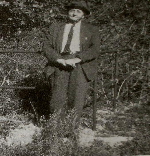
Figure 12. James C. “Cent” Walker
(1876-1965), last sheriff of Pontotoc, C. N. and grandson of Robert
L. Cochran stands before Cochran Cemetery in December 1964.
Walker’s father (Tandy C. Walker) was nephew of Choctaw Gov. /Col.
Tandy Walker. Tandy C. Walker married R. L. Cochran’s daughter,
Isabella. The couple is buried at Frisco (old Stonewall) Cemetery
located a mile east of Cochran across Clear Boggy. A. O. Cochran,
older brother of R. L. Cochran, is buried nearby (Fig. 15). Source
of Fig. 12: Bill Tinsley, Chronicles of OK., Vol. 76, No. 4, pp.
436-449.
A modern picture of Cochran’s
Cemetery taken April 20, 2013 during a tour of Phillips Expedition
at Muddy Boggy and Cochran’s Store along the Dragoon Trail by Bruce
Schulze, Ken Martin and Carroll Messer is shown in Figure 13. A
view of the Dragoon Trail 140 yards south of the Cemetery (at old
Cochran’s Store near Camp Kagi) is shown in Figure 14.
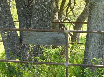 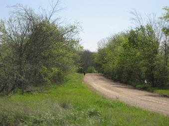
Figure 13. Cochran Cemetery. Source:
Ken Martin Figure 14. Camp Kagi at Cochran’s Store.
PHILLIPS RETURNS TO FT. GIBSON
As soon as Phillips’ scouts returned
from their southern ride to deliver President Lincoln’s amnesty
proclamation mission, Col. Phillips decided his mission was
satisfied. On the afternoon of February 15, 1864, he began a hard
march back north along the Dragoon Trail toward old Ft. Holmes on
the Canadian. As he was leaving Cochran, he probably set fire to
Colbert Institute located a mile east of town. This inspiration
seems to have caused Phillips to write his final “Surrender or Die”
letter to the vanquished Creek leader Col. McIntosh. Then a strange
thing happened. It began to rain, and rain it did for at least two
days. Late on February 16, Phillips writes from near Little River
Town across the South Canadian (aka Edwards Post across Little River
from old Ft. Holmes) of his safe return in the driving rain, so hard
that he expects major river crossings to soon flood.
The sudden rain seems to have saved
some of Colbert Institute. Historical records suggest the Institute
was only partially destroyed by fire during the war. Following some
repairs, the school was beginning to be used again (as a
neighborhood school) by 1868 and was fully restored (to a National
boarding school) by 1870. However, its education objectives had
been changed by the Chickasaw’s to emphasize practical training
(less religion and arts) during national reconstruction. As Gov.
Winchester Colbert (Fig. 16) lost his reelection bid in 1866 and
retired from public service, the former name of “Colbert Institute”
faded away. More fire soon destroyed the rest. The repaired dorm
burned in 1874, and the school house in 1880. Finally, all of old
Cochran was gone. Only the small plot of Cochran’s Cemetery
remains, guarded by a well-built pipe fence (Fig. 13).
Figure 15. Grave of A. O. Cochran at
Frisco. Figure 16. Chickasaw Gov. Winchester Colbert,
Source: Fig. 16, OHS and Chickasaw Nation.
Col. Phillips continued cavalry
raiding the Seminole and Creek Nations as he returned with his
infantry along the Dragoon Trail directly to Ft. Gibson, bringing
with him a large captured ox train.The 14th Kansas
raided north and northwest along Indian migration trails (toward
Tulsa). The Oak Ridge Mission was probably burned as Phillips march
by on February 17. All of Phillips command arrived safely back in
Ft. Gibson, Phillips by 2-24, where they were mustered and inspected
on February 29, 1864. Phillips’ final claim for his Expedition was
that they had marched about 400 miles and killed a total of 250
(rebel) men and captured a large ox train. Federal casualties were
reported as only 4 men wounded and 3 missing.
Phillips’ Expedition only increased
Confederate morale and determination to continue the war, especially
among the senior commanders in Indian Territory: MG S.B. Maxey, BG
D.H. Cooper, BG S. Watie, BG R.M. Gano and Col. T. Walker. A month
later, most of Maxey’s troops marched into Arkansas and joined the
main Confederate Army in repelling the Federal invasion at Prairie
d’Anne and Poison Spring. Returning home, Watie and Gano increased
their raiding of supply trains intended for supporting Phillips at
Ft. Gibson. Successful cavalry raids included the capture of the
steamboat J.R. Williams in June and a large wagon train at
Cabin Creek in September. Even Ft. Smith was threatened by Cooper
and Maxey by late July 1864.
LOCATION OF THE BATTLE OF MIDDLE
BOGGY
Circumstantial evidence suggests that
the battlefield was located along the Dragoon Trail (or Texas Cattle
Trail) near its crossing of Middle Boggy River between the Ft.
Smith-Ft. Arbuckle junction just south of Allen, OK and the small
community of Steedman about 2 miles southwest of the Middle Boggy
River crossing. The most likely site for the battlefield is on the
B&L Road four miles south-southwest of Allen, in extreme
northeastern Pontotoc County, Oklahoma. The Confederate outpost is
believed to have been located near where the Texas Cattle Trail
(Dragoon Trail, heading S20W) crossed the local B&L Road. This site
lies about 500 yards east along the curvy B & L Road from the bridge
crossing of Little Sandy Creek. The new B&L bridge, named the
Richard V. Wallace Memorial Bridge, is about 300 yards east of the
Chickasaw / Choctaw National Boundary Line. See Figure 17.
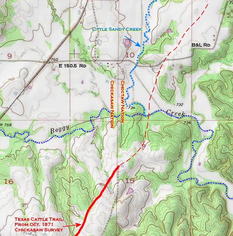
Figure 17. Proposed Location of
Battle of Middle Boggy, Pontotoc County, Oklahoma. Source: Ken
Martin, Bartlesville, OK (topo & Little Sandy Creek location);
author, Location of Texas Cattle Trail from 1871 BLM Initial Land
Survey.
The battle likely moved south along
the Dragoon Trail from the outpost through a small saddleback
feature all the way to the River, 900 yards to the south-southwest
down the natural open valley of (the original, wavy blue-line
channel in Fig. 17) Little Sandy Creek into Middle Boggy. (A flood
control channel change was made several decades ago to Little Sandy
and now it crosses the old Dragoon Trail near Middle Boggy.)
Prospective campsites near spring water lay on both sides of the
Trail. One such attractive site, having a great view of the likely
battlefield, has been termed “Battle Hill.” See Figure 18.
However, given that many of the Confederates who fought in the
battle probably had just ridden several miles to the outpost during
one cold February night, camping locations may not have been
critical. Keeping the Federals out of the Chickasaw Nation was.
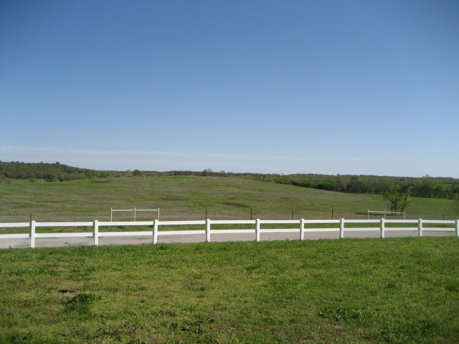
Figure 18. Dragoon Trail lies
parallel to and just beyond B&L Road in this picture of “Battle
Hill” looking south. Muddy (Middle) Boggy River lies behind the
hill in the trees. Little Sandy Creek lies just outside to the
right. Source: author
Col. Phillips headquarters for the
night of 2-13 (Camp Kansas) were most likely located just south of
Allen and the trail junction (on high prairie land near Motes
Springs) and not across Middle Boggy River, otherwise Phillips would
have been in the Chickasaw Nation-- a well-known fact in 1864 which
Col. Phillips surely knew. At this site (looking north in Fig. 19)
where a tall radio tower is now mounted nearby along Camper Road for
Camp Kansas, Phillips would have a nearby cross road junction to Ft.
Smith (which he may have used for his dispatch of 2-14 to Brig. Gen.
Thayer, commanding at Ft. Smith), well-known clear headwaters
springs, an elevated open space for good defensive purposes, and
most of his little army. While the 1st IHG arrived at the
battlefield that afternoon, neither the 3rd IHG nor the wagon train
did. Thus, the battlefield itself was most likely located a few
miles ahead of Camp Kansas, very near the Middle Boggy crossing. The
remaining question is “On which side of Middle Boggy, the east or
west?”
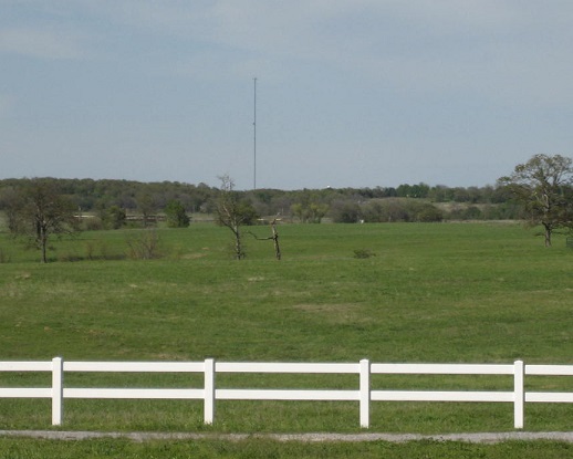
Figure 19. Proposed site for Camp Kansas lies on the upland
prairie just beyond the radio tower, a mile south of Allen. Dragoon
Trail passes near tower, coming directly S20W toward the camera,
where it passes the camera position 100 yards to the right (east).
Source: author
Several bits of evidence suggest the
northeast side (nearer to Allen). Col. Phillips initially reports
from the Choctaw Nation on 2-14 that the Indian enemy was Choctaw
(an east-sider) and not Chickasaw (a west-sider). Gen. Cooper notes
the enemy is 45 miles from Boggy Depot. The east side (nearer to
Allen junction and Phillips’ HQ that night) fits this distance
better. The distance Col. Phillips later states Camp Kansas is from
Camp Kagi is 21 miles, which fits nicely with his HQ being near
Allen, and not at the river crossing 2 miles ahead with the bloody
battlefield likely being on the west side. The Confederates were
overwhelmed and slaughtered. Confederates defending an east side (or
suicide) outpost directly exposed to an enemy cavalry charge with
rebel backs to the river, logically fits the results better. Willetts
had good flanking attack paths from Allen junction with two pincer
routes well hidden by terrain and linked to an east-side outpost. A
path for a western flank attack along the old Marcy Trail (say OK 1)
from Allen lay just to the west along Little Sandy Creek, and an
eastern flank attack could easily follow the path of OK 48 highway
from Allen as it would lie just east of the Dragoon Trail behind
some hills. Both flanking routes would arrive just behind an
east-side outpost without fording Middle Boggy. The tired,
poorly-armed Confederates would have been sitting ducks to such a
large well-hidden mobile three-column attacking force. Capt.
Kaufman’s two howitzers could have signaled the start of the attack
on the outpost from several elevated positions near the Dragoon
Trail east of the river crossing. A Confederate casualty rate
exceeding 50% suggests this is what happened, given the reported
zero Federal casualties.
REFERENCES
Civil War
Official Records
of the War of the Rebellion, War Department, Washington, D. C. in
the following:
Volume 34 (1891): Part I – Reports,
pp. 106-12; Part II - Correspondence: pp. 190-92, 208, 249, 272,
281, 301-02, 329-30, 467-68, 856-62, 874-77, 958-61, 969-70, 994-97.
Volume 41 (1893): Part III -
Correspondence: pp. 983-84.
Website:
http://digital.library.cornell.edu/m/moawar/waro.html/
Many postings on Phillips Expedition
and related topics at
www.History-Sites.com on Board of Indian Territory.
Kansas Military History accessed thru
Kansas Memory of 14th Kansas Volunteer Cavalry.
Middle Boggy and Dragoon Trail
Lieutenant Simpson’s California Road
Across Oklahoma. Robert H. Dott. Chronicles of Oklahoma, Vol. 38,
No. 2, 1960, p. 166.
Lieutenant Averell’s Ride at the
Outbreak of the Civil War. Muriel H. Wright. Chronicles of
Oklahoma, Vol. 39, No. 1, 1961, pp. 2-14.
Buffalo Valley: An Osage Hunting
Ground. Orel Busby. Chronicles of Oklahoma, Vol. 40, No. 1, 1962,
pp. 22-35. See p. 23 & p. 28.
Cochran (Pontotoc, Camp Kagi, Gov.
Colbert)
Reminiscences of Old Stonewall.
George W. Burris. Chronicles of Oklahoma, Vol. 20, No. 2, June
1942, pp. 152-158.
Remembering Stonewall, Pontotoc
County, Chickasaw Nation. Bill Tinsley. Chronicles of Oklahoma,
Vol. 76, No. 4 (Winter 1998-99), pp. 436-449.
Lieutenant Averell’s Ride at the
Outbreak of the Civil War. Muriel H. Wright. Chronicles of
Oklahoma, Vol. 39, No. 1, 1961, pp. 2-14.
Sarah Ann Harlan: From Her Memoirs
of Life in the Indian Territory. Muriel H. Wright. Chronicles of
Oklahoma, Vol. 39, No. 3, 1961, pp. 322-333. See Cochran on pp.
318-319.
Leaders and Leading Men of the Indian
Territory—Choctaws and Chickasaws. Harry F. O’Beirne. American
Publishing Association, Chicago, 1891, 221 pages.
Governor Daugherty (Winchester)
Colbert. John Bartlett Meserve. Chronicles of Oklahoma, Vol. 18,
No. 4, December, 1940, pp. 348-356.
Camp Butler - May 12, 1863. Charles
De Morse. Clarksville (Texas) Standard. (Article in newspaper
describes the 29th Texas Cavalry’s move from Fort
Arbuckle, I.T. thru Cochran to Camp Butler prior to the 7-19-1863
Battle of Honey Springs, IT.
ACKNOWLEDGMENT
A special thanks is due Mr. Ken
Martin, Administrator of
www.History-Sites.com , for his continual guidance and support
during the production of this document. Mr. Martin provided several
detailed articles on historical events related to Phillips’
Expedition, whose sources were unknown or not available to the
author. The website’s postings by Mr. Danny Knight, whose
Gs-grandfathers were Chickasaw Gov. Winchester Colbert and Robert L.
Cochran, were most informative and inspirational. Many, many
other’s postings provided important bits and pieces of the
Expedition’s historical puzzle. Mr. Bruce Schulze of
www.civilwaralbum.com
provided the initial photographic venue for presentation of the
author’s initial ideas on Phillips’ Expedition.
ATTACHMENT
Official Records,
Volume 34, Part II, p. 190.
190
Louisiana and the Trans-Mississippi Chapter XLVL
Circular Hdqrs. First Brig., Army of the Frontier
Fort Gibson, C. N., January 30, 1864
Soldiers! I take you with me to clean out the Indian Nation south of
the river and drive away and destroy the rebels. Let me say a few
words to you that you are not to forget. Do not begin firing in
battle until you are ordered. When you fire, aim low, about the
knee, or at the lower part of a man's body, if on horseback. Never
fire in the air. Fire slowly and never until you see something to
shout at that you may hit. Do not waste your ammunition. Do not
straggle or go away from the command; it is cowards only that leave
their comrades in the face of the enemy; nearly all the men we get
killed are stragglers. Keep with me close and obey orders and we
sill soon have peace. Those who are still in arms are rebels, who
ought to die. Do not kill a prisoner after he has surrendered. But I
do not ask you to take prisoners. I ask you to make your footsteps
severe and terrible.
Muscogees! the time has now come when you are to remember the
authors of all your sufferings; those who started a needless and
wicked war, who drove you from your homes, who robbed you of your
property. Stand by me faithfully and we will soon have peace. Watch
over each other to keep each other right, and be ready to strike a
terrible blow on those who murdered your wives and little ones by
the Red Fork along the Verdigris or by Dave Farm Cowpens. Do not be
afraid. We have always beaten them. We will surely win. May God go
with us.
Wm. A.
Phillips
Colonel, Commanding
.
|